Loisirs 74
Free access · May to October

Mont Joly

Iconic summit at 2,525 m elevation offering a 360° panorama over the Mont-Blanc massif, Beaufortain, Aravis, Fiz and Bauges ranges.

Mont Joly summit at 2,525 m with panoramic views over the Mont-Blanc massif, Saint-Gervais-les-Bains, Haute-Savoie
DimiTalen · CC0 · Wikimedia Commons
At a glance
Type
Mountain summit · Viewpoint
Access
Free · No charge
Duration
5 to 8 hours round trip depending on route
Best season
June – October
Parking
Several departure parking areas depending on route
Dogs
Allowed on leash
Stroller
Not suitable
Town
Saint-Gervais-les-Bains

What is Mont Joly

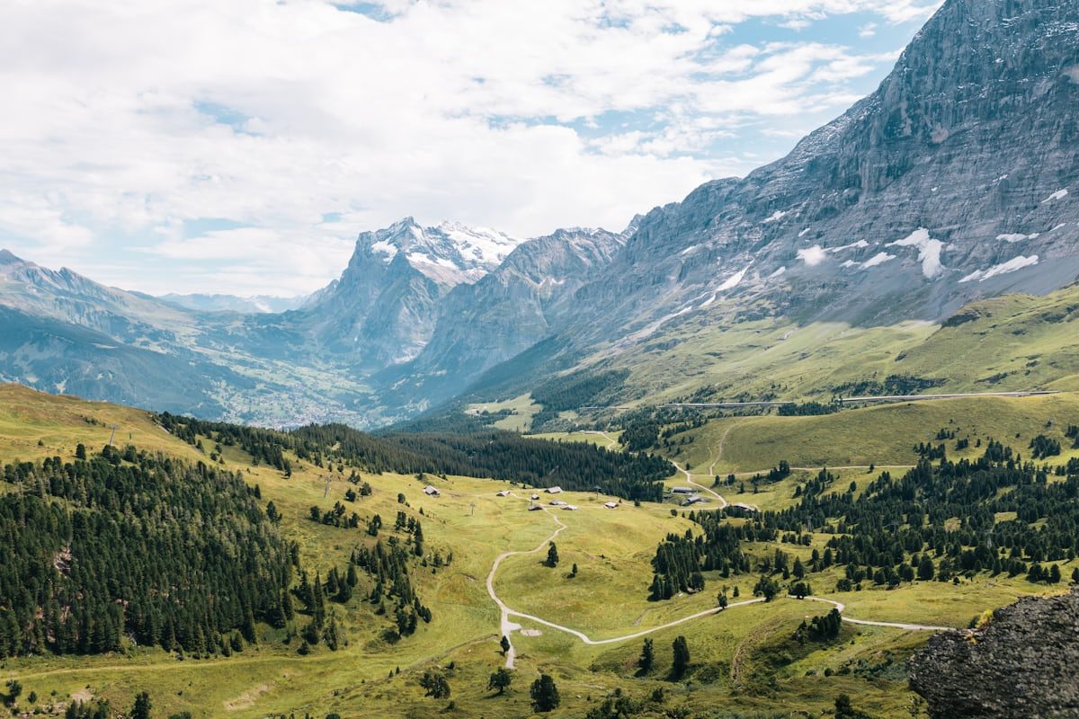
Mont Joly is a 2,525 m summit located in the Beaufortain massif, on the border between Saint-Gervais-les-Bains, Megève and Les Contamines-Montjoie, in Haute-Savoie. A true natural viewpoint facing the Mont-Blanc massif, it offers an exceptional 360° panorama from its summit, where an orientation table is located.

Mont Joly is accessible via several hiking routes, with the main starting points at Saint-Nicolas-de-Véroce (Plateau de la Croix), Bettex via Les Communailles, Planay hamlet from Megève, or Baptieu hamlet from Les Contamines-Montjoie. The climb is challenging and sustained, crossing alpine meadows and forests before reaching the mineral ridges of the summit.

The summit features technical installations (mountain rescue radio relay, weather antennae) and a visitor logbook box. Hikers can reach the summit via two main variants: Épaule du Mont Joly (the most frequented route) or Panse (less-used route). The ascent passes through several remarkable points: Mont Joly refuge (2,002 m), Mont Géroux (2,288 m), and the arrival of the Épaule chairlift (closed in summer).

Activities

What you can do here

Practical

Practical information

Address
Several possible departure points: Plateau de la Croix (Saint-Nicolas-de-Véroce), Le Bettex (Les Communailles), Planay hamlet (Megève), Baptieu hamlet (Les Contamines-Montjoie) View on map
Coordinates
45,825959° N — 6,692936° E View on map
Altitude
2,525 m
Opening
Accessible May to November depending on snow conditions. In winter: ski touring or snowshoeing only. The summit is inaccessible in case of unstable snow.
Price
Free
Parking
Free parking at Plateau de la Croix, Bettex, Planay or Baptieu depending on chosen route. Limited arrival in peak season.
Animals
Dogs accepted on leash (alpine meadows with herds grazing in summer)
Accessibility
Not accessible by stroller or wheelchair. Challenging hike reserved for experienced hikers.
Access duration
5 to 8 hours round trip depending on route and starting point. Ascent: 3 to 4 hours. Descent: 2 to 3 hours.
Contact
Saint-Gervais Mont-Blanc Tourist Office — 04 50 47 76 08
When to visit

When to visit

The best period to hike Mont Joly extends from June to October, when trails are snow-free and passable. July and August offer the most stable conditions, but also the highest visitor numbers. Late May and early June still have persistent snowfields on high slopes. September and early October offer exceptional light and fewer crowds, but days shorten and mountain refuges close. In winter, Mont Joly is accessible by ski touring or snowshoes, but requires good terrain knowledge and understanding of snow conditions. The summit is very exposed to lightning if storms approach: descend immediately if weather deteriorates.
Nearby

Where to eat, drink, stay

Restaurant, café, bar

Serving visitors to this site? Appear here.

Become a partner
Photos

Gallery

FAQ

Frequently asked questions

Is access to Mont Joly free?

Yes, access to Mont Joly is free and free of charge year-round. Only the Mont d'Arbois cable car (to shorten the route from Megève) is paid.

What is the best route to climb Mont Joly?

Mont Joly is accessible via several routes. The departure from Plateau de la Croix (Saint-Nicolas-de-Véroce) is the most direct: 4 km, 1,000 m elevation gain, approximately 3 hours ascent. From Bettex (Les Communailles): 5 to 6 hours round trip. From Megève (Planay hamlet): 6 to 8 hours round trip.

What is the difficulty level of the Mont Joly hike?

The Mont Joly hike is challenging and reserved for experienced hikers. Elevation gain of 850 to 1,200 m depending on the route. The slope is sustained after Pavillon du Mont Joly, with steep and rocky passages on the summit section (Épaule or Panse). Bring proper hiking boots, water and warm clothing.

Can you sleep at the Mont Joly summit?

No, there is no refuge at the Mont Joly summit. The Mont Joly Chalet-Refuge is located at 2,002 m elevation, before the final ascent. It offers meals and lodging by reservation. From the refuge, allow another 1.5 to 2 hours to reach the summit.

Are dogs allowed on Mont Joly?

Yes, dogs are allowed on Mont Joly trails but must be kept on a leash, especially in alpine meadows where cattle, goats and sheep graze from June to September. Mont Joly is not located in a nature reserve.

What is the best season to climb Mont Joly?

The best period for Mont Joly extends from June to October. July and August offer the most stable conditions. September and early October are ideal for solitude and light. Late May and early June: persistent snowfields. In winter: ski touring or snowshoeing only.

Sources

Sources & verification

Multi-source verification at publication date. Information may change — confirm with the official operator before travelling.

Published 14 mai 2026·Updated 14 mai 2026

Directions