 Free
Free
Plage de La Brune
Veyrier-du-Lac
Blue Flag since 2009 (confirmed 2026). 7,000 sqm of lawn and sandy banks with paddling pool, T-shaped pontoon, diving board, snack-restaurant. Tiralo on site.
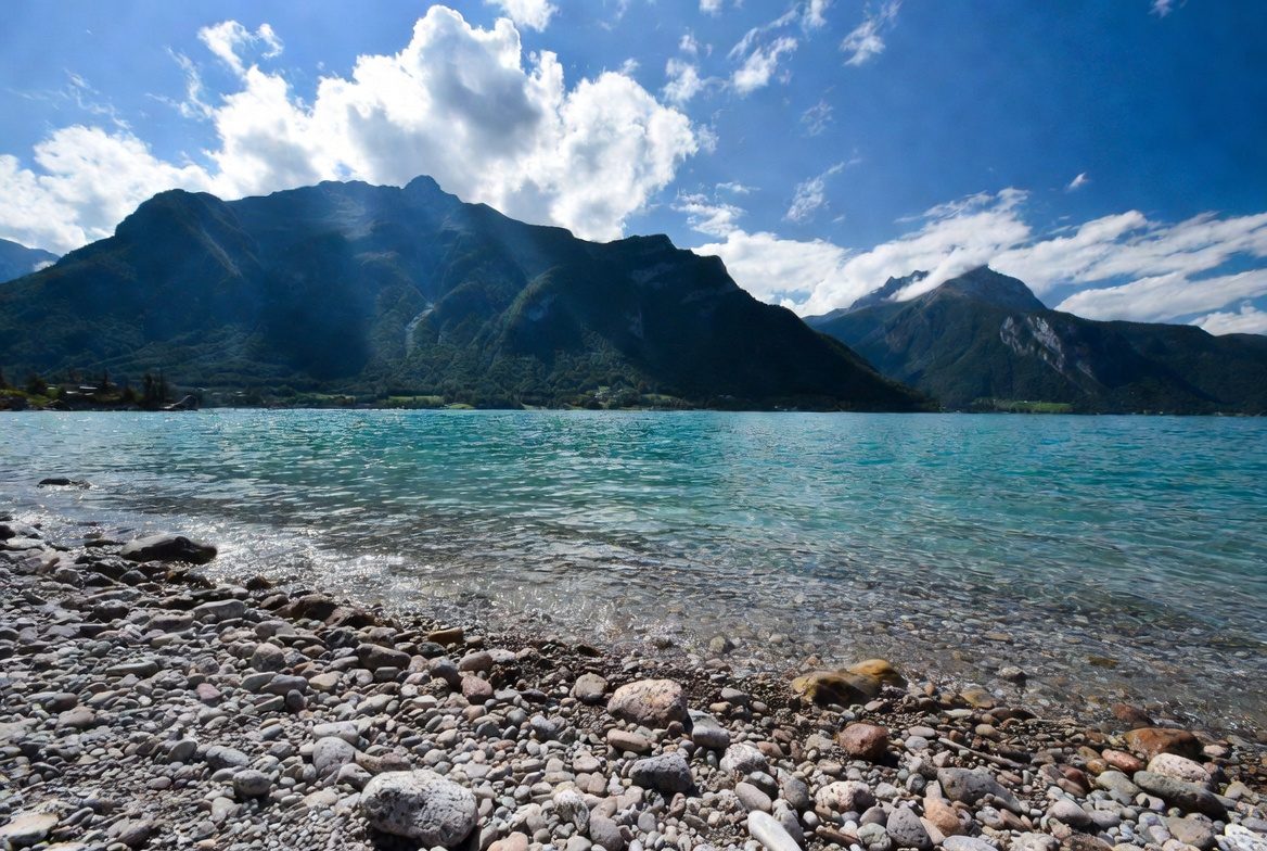
Concrete panoramic platform at 1,254 m altitude, the sole remaining vestige of the former Mont Veyrier cable car, offering sweeping views over Lake Annecy and a 180° panorama from Salève to the Bauges.

The Belvédère du Mont Baron is a concrete panoramic platform situated at 1,254 m altitude on the ridge overlooking Veyrier-du-Lac and Lake Annecy. It is the sole remaining vestige of the former Mont Veyrier cable car, inaugurated on 29 July 1934, decommissioned in 1984 due to the cost of safety upgrades, with its upper station demolished in 2001 following a fatal accident in 1998. At its peak in 1948, this cable car transported nearly 70,000 passengers per year in just 7 minutes from Veyrier-du-Lac, with two 25-passenger cabins, setting two world records: the longest cable span without intermediate pylons (1,525 m) and the greatest elevation gain (808 m).
The platform offers one of the most spectacular panoramas in the Annecy region: a sweeping view 800 m above the lake, a 180° panorama from the Bauges massif in the west to Salève and the Jura in the north, with Mont Blanc, the Aravis and La Tournette visible to the east. The viewpoint sits on the ridgeline between Mont Baron (1,299 m, summit 10 minutes above the platform) and Mont Veyrier (1,291 m, 30 minutes further north via the ridge path). Together they form a continuous balcony overlooking Lake Annecy, highly prized by hikers, photographers and bivouac campers. An orientation table is installed on the platform. The site is also renowned for its spectacular sunsets over the lake.
From Annecy (~10 min), reach Veyrier-du-Lac via D909a (east shore of the lake). Park at the small port at Veyrier-du-Lac or at public parking areas in Annecy-le-Vieux near Chemin Rural de la Montagne. Note: road access to Col des Contrebandiers and Pré Vernet is prohibited to motor vehicles since 29 July 2024 (municipal order of Veyrier-du-Lac and Annecy). Mandatory on-foot departure from the lakeside. Allow 1 h 30 to 2 h of walking to the viewpoint.
Open in MapsBus line 20 from Annecy to Veyrier-du-Lac (free from 1 July to 31 August). Then 1 h 30 walk to the viewpoint via the marked GR Lake Annecy Circuit trail.
Open in MapsAccess possible by bike to the foot of the trails (Plan Sagran, parking prohibited to cars), then on-foot ascent mandatory. Cycle path along the lake from Annecy.
Open in MapsBeen there? Share your photos — we'll add them to this page with credit. Tag #loisirs74 or email photos@loisirs74.fr
Yes. Access to Belvédère du Mont Baron is free and open year-round. It is a hiking trail in free access with no admission fee or toll.
Since 29 July 2024, road access to Col des Contrebandiers is closed to vehicles. You must park by the lake (Veyrier-du-Lac or Annecy-le-Vieux) and hike up the marked Mont Baron trail. Allow 1 h 30 to 2 h of walking.
Belvédère du Mont Baron (former cable car platform) sits at 1,254 m altitude. Mont Baron summit, 10 minutes higher, reaches 1,299 m.
Yes. Wild bivouacking is tolerated at Belvédère du Mont Baron and widely practiced for sunset viewing. The platform is a popular bivouac spot. Respect guidelines: tent pitched after 19:00, taken down before 09:00, no fires, pack out all waste.
Yes, from age 5 with supervision. The Belvédère du Mont Baron trail has rocky sections and some exposed passages secured by cables. Not suitable for young children or strollers.
April to October. Summer (June–September) offers the best weather but high crowds. Spring and autumn are quieter. In winter, the Belvédère du Mont Baron trail is icy and slippery; reserved for experienced hikers with proper equipment.
Since 29 July 2024, the road has been closed to motor vehicles as part of the Mont Veyrier Massif Management Plan 2024-2029. The closure aims to facilitate emergency vehicle access (often blocked by chaotic parking), protect biodiversity and regulate growing visitor numbers.
The Mont Veyrier cable car was inaugurated on 29 July 1934 by banker Léon Laydernier. It transported 2 million passengers over 50 years, reaching 70,000 passengers in 1948. It held two world records: 1,525 m cable span and 808 m elevation gain without intermediate pylons. Closed in 1984 for economic reasons (cost of safety upgrades), the upper station was demolished in 2001 after a fatal accident in 1998.
Multi-source verification at publication. Information may change — confirm with the official operator before travelling.
Nearby
Other places to explore in the area and in the same category
Free
Blue Flag since 2009 (confirmed 2026). 7,000 sqm of lawn and sandy banks with paddling pool, T-shaped pontoon, diving board, snack-restaurant. Tiralo on site.
 Free
Free
The largest free beach on Lake Annecy: 400 m of grass and sand, summer lifeguards, free showers and toilets. Albigny district, Annecy.
 Paid
Paid
Casino Impérial Palace at 32 avenue d'Albigny in Annecy, on the lakeside: slot machines, roulette, blackjack and poker, 5-star hotel and gourmet restaurant.
 Free
Free
Essential viewpoint at 1299 m above Lake Annecy: panoramic trails, Mont Blanc views, old cable car platform. Free access year-round from Annecy-le-Vieux.
Free
Iconic 1,291 m summit overlooking Lake Annecy with 360° views of the Bauges, Aravis and Mont Blanc. Ridge trail, free year-round access, starting from Petit Port.
 Free
Free
The Thiou, the outflow of Lake Annecy: 3.5 km through the old town, 62 Sadi Carnot floodgates, Pont des Amours, Palais de l'Île, heritage walk.